
There were several trails and sections of trails, cut-offs, and detours used by the anywhere from 250,000 to 500,000 emigrants in the mid 1800's, before the transcontinental railroad came into widespread use. Some of them are below.
Some of the maps provided only show some waypoints, others show part of the presumed actual routes. And, of course, mostly the Nevada portions because, well, this is Forgotten Nevada and who cares about them other states. Keep in mind that some of these are well known, others educated guesses, and some are wild guesses. Routes changed, were improved, short-cuts were discovered and abandoned, and parts of many routes were fluid. For any explanation of waypoints, consult Trails West and their fine collection of trail guides, available at very reasonable prices.
Just to be clear, when it says "Download Google Earth File " what you will actually be downloading is a Google KMZ file. You will need to use Google Earth to view it.
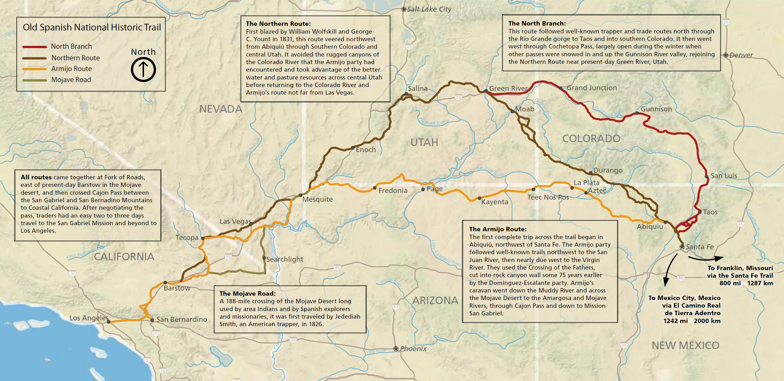
Spanish Trail View Spanish Trail Map
Probably the earliest trail in Nevada, being used as early as 1831 and maybe even before that.
The map, from the National Park Service, shows the various routes and a bit of the Trail's history.
California Trail View California Trail Map Download Google Earth File
In May 1841, however, the first group of emigrants, the Bidwell-Bartleson party, met near Independence, Missouri and blazed their way west. At Fort Hall, in present-day Idaho, about half of the party opted to take the Oregon Trail, but the rest vowed to reach California. They abandoned their wagons in eastern Nevada. On horseback and on foot, the party staggered across the Fortymile Desert and entered California via the Walker River. Starving and nearly naked, they finally reached the Central Valley in November. Three years later, the Stephens-Townsend-Murphy party followed suit; they also crossed Nevada along the Humboldt River to the Fortymile Desert but decided to ascend the Truckee River. Eventually they ascended the Sierras via Emigrant Gap and stumbled down to Sutter’s Fort. Soon afterward, in 1846, came the infamous Donner-Reed party, which crossed western Nevada on route similar to the one traveled by the Stephens-Townsend-Murphy party. The Sierra snows, however, forced the party to halt near present-day Truckee, California where they endured several months of suffering, starvation, death, and some cannibalism until rescuers could reach the survivors. The January 1848 discovery of gold, however, turned all eyes toward California. Soon afterward, tens of thousands of “Forty-Niners” and other emigrants rushed hastily toward the gold fields, many of them over Carson Pass. (Thousands of others, meanwhile, headed there by sailing either around Cape Horn or by taking a ship to Panama, negotiating a trail across the narrow isthmus, and waiting for a Pacific coast sailing ship heading north.) At the same time, California was making abrupt political changes. The Treaty of Guadalupe Hidalgo, signed in February 1848, brought California under U.S. control, and in 1850, Congress made it the 31st state as part of the Compromise of 1850. Westbound traffic over the California Trail was heavy for the next several years, gradually shifting over to the Donner Pass route; meanwhile, other routes to California – over the Lassen, Nobles, and Beckwourth trails along with the Walker River-Sonora Route – opened up. After 1852, traffic over the California trail subsided, and the number of people heading east often equaled the ones going west, with many of those going to Oregon instead. Various California Trail routes remained active, however until the transcontinental railroad was completed in 1869.
-https://www.nps.gov/cali/learn/historyculture/index.htm
Carson River Route Download Google Earth File
The Carson Route (or “Carson River Route”) was opened in 1848 from west to east by remnants of the Mormon Battalion who came to California in 1846 with the US Army to assist in the fight against Mexico.
-http://canvocta.org/carson-river-route/
One of the main routes for emigrants coming from the east to California and points West headed south at the Humboldt Sink to avoid Donner Pass. Most of the route through Churchill County was one of the worst feared sections, passing through the infamous Forty Mile Desert. It was created around 1848. Unfortunately, by the time emigrants reached this desertnorth of Fallon, it was summer-- dry and hot.
"Imagine to yourself a vast plain of sand and clay; ...the stinted sage, the salt lakes, cheating the thirsty traveler into the belief that water is near; yes, water it is, but poison to the living thing that stops to drink.... Burning wagons render still more hideous the solemn march; dead horses line the road, and living ones may be constantly seen, lapping and rolling the empty water casks (which have been cast away) for a drop of water to quench their burning thirst, or standing with drooping heads, waiting for death to relieve them of their tortures, or lying on the sand half buried, unable to rise, yet still trying. The sand hills are reached; then comes a scene of confusion and dismay. Animal after animal drops down. Wagon after wagon is stopped, the strongest animals are taken out of the harness; the most important effects are taken out of the wagon and placed on their backs and all hurry away, leaving behind wagons, property and animals that, too weak to travel, lie and broil in the sun.... The owners hurry on with but one object in view, that of reaching the Carson River before the boiling sun shall reduce them to the same condition.... The desert! You must see it and feel it in an August day, when legions have crossed it before you, to realize it in all its horrors. But heaven save you from the experience. "
-Eleazar Stillman Ingalls, August 5, 1850
This is a description of the trail as it crosses the northern part of Churchill County, where Interstate 80 goes now:
"West of Lovelock US 40 leaves the Humboldt River to skirt the southern edge of the Trinity Range and cross the old Forty-mile Desert; the highway pursues a course considerably north of the early road, one route of which went south and one just north of the Humboldt Sink. Early travelers knew that their last water before crossing the desert was to be found in the Humboldt Slough, which drained south. "Even the very wagons seem to know that we are off today for the great adventure-in sand, volcanic ash,' alkali, furnace heat, and the stench of putrid flesh-We crossed along the edge of an immense baked plain with the fetid stinking slough for a guide, although the wreckage along the way almost paved our route. ... It must have been here that one emigrant said he counted a dead animal every 106 feet." The beasts died of various causes, among which was the poisonous water in this stretch. Of the water flowing into the Sink itself. Mark Twain wrote that he and his prospecting friends tried to drink it, but it was like drinking lye, "and not weak lye, either." They put molasses in it, they tried pickles, they made coffee of it-but as one of them said, it was "still too technical."
- The WPA Guide to 1930's Nevada
The trail "officially" starts at Marker CR-1, where it forks off to the south from the existing California Trail. The map shows the Trails West marker numbers.
Greenhorn Cutoff
Download Good Earth File
Not really a cutoff, since it added some distance to the journey. More like a detour.
The Greenhorn Cutoff was actually an alternate route around Carlin Canyon that allowed emigrants to bypass the four crossings of the Humboldt River required on the main California Trail. The crossings were especially difficult and dangerous during high-water years. The cutoff began near Hunter Exit 292 on I-80 and wound north around Carlin Canyon before turning south alongside Dry Susie Creek to reconnect with the main California Trail. Contrary to its derisive name, the Greenhorn Cutoff was actually several miles longer than the main trail and had its disadvantages, including the fact it was more mountainous and drier than the main trail. Additionally, the Carlin Canyon crossings were not actually very bad most years.
-https://ctic.oncell.com/en/20-greenhorn-cutoff-225078.html
Walker River - Sonora Route
Download Google Earth File
The first emigrants to cross the Sierra Nevada Mountains into Tuolumne County were the members of the Bidwell-Bartleson Party of 1841. They followed a convoluted route from the headwaters of the Walker River, across a remote mountain pass, down to the Clark Fork of the Stanislaus River, and eventually to the San Joaquin Valley. In 1852 the Clark-Skidmore Party, led by a group sent out from Columbia, established a new route through the mountains which would become known as the Walker River Trail, although some still referred to it as the Sonora Pass Trail. The following year more than two thousand emigrants used the new trail to the Southern Mines. By 1854, though, word of the difficulties along the trail had spread and only a trickle of emigrants chose the route. Soon afterward, the Sonora Pass Trail was abandoned. Today’s Highway 108 parallels the old emigrant wagon route.
-https://www.sierracollege.edu/ejournals/jsnhb/v2n2/trails-Sonora.html
Beckwourth Trail
Download Google Earth File [Sparks to Quincy, CA]
The Beckwourth Trail was one of the significant trails that crossed the Sierra. Its main claim to fame was that it had the lowest elevation crossing of the mountains and was a much needed alternative to the difficult mountain crossings on the Carson and Truckee Trail routes. It departed from the Truckee Trail in present day Sparks, Nevada and headed west to Marysville, California.
-https://emigranttrailswest.org/virtual-tour/under-construction/
Truckee Route
Download Google Earth File
The Truckee Route was opened in 1844 by the Stephens-Townsend-Murphy Party. They turned off the Oregon Trail at the Raft River and traveled into northeastern Nevada. Following the Mary’s River (Humboldt) west they crossed Nevada to the Humboldt Sink. After crossing the Forty-mile Desert they followed the Truckee River and with great difficulty proceeded up the canyon. Getting over the summit was an even greater ordeal.
-http://canvocta.org/emigrant-trails-of-nevada-and-california/truckee-river-route/
Reaching Humboldt Sink in 1844, the Elisha Stephens (sometimes spelled Stevens) Party confronted the same dilemma that the parties of 1841 and 1843 had faced – namely, how to cross the forbidding Sierra Nevada. At that critical juncture, they met the Paiute Indian chief whom they named "Truckee." He provided directions on how to follow the Truckee River to a pass over the Sierra Nevada (usually known as Donner Pass but more correctly as Stephens Pass). After many hardships, the Stephens Party made it to Sutter's Fort, thereby completing the opening of the first overland wagon route to California. Improvements in 1845 and 1846 (via Dog Valley and Roller Pass) on the first route over the Sierra Nevada would turn it into an established wagon trail. Later, this trail would be transformed into the Lincoln Highway, Highway 40, and finally today’s Interstate 80.
-https://www.sierracollege.edu/ejournals/jsnhb/v2n2/trails-Truckee.html
Applegate Trail
Download Google Earth File (Lassen Meadows to California Border waypoints only)
The Applegate Trail, first laid out and used in 1846, was a southern alternative to the western-most segment of the Oregon Trail, with its users leaving the original Oregon City-bound Oregon Trail route near Ft. Hall, in what is now southeastern Idaho, and following the California Trail west along the Humboldt River, to where the Applegate Trail branched off to the northwest. Conceived as being safer, quicker, and more secure from possible British control should war break out over the Oregon Question, the trail (which was also known to Oregonians as Applegate's Cut-off, the Southern Emigrant Road, and simply as the South Road or Southern Road during its main period of use, 1846-1860) was intended to bring wagon trains of settlers into the Willamette Valley. Although the number of emigrants who used the Applegate Trail was comparatively modest, it had particular significance in the settling of the Rogue Valley during the 1850s. Eastward over the Cascade Range and beyond Lower Klamath Lake the route they blazed crossed northeastern California's rugged volcanic Modoc Plateau to Goose Lake. From there they crossed the Warner Mountains' Fandango Pass and continued over the desolate Black Rock Desert, until the new "cut-off" joined the well traveled California Trail along northern Nevada's Humboldt River (the junction was located beneath what is now the northern tip of Rye Patch reservoir). For much of the new route's length, it passed through parched country—a sea of sagebrush. While most of the men stayed on the Humboldt to rest their horses and await the first travelers, Jesse Applegate continued east to Ft. Hall, arriving by early August, to promote the new route to Oregon-bound emigrant trains— and it was largely due to this that the trail soon came to bear his name.
-https://www.oregonencyclopedia.org/articles/applegate_trail/
From Fort Hall, Idaho, the route headed south following the Humboldt River before passing through the Black Rock Desert in present-day Nevada. The trail then entered Northern California and passed Goose and Tule lakes
Hastings Cutoff
Download Google Earth File
Lansford Hastings, lawyer, explorer, and later Confederate soldier, blazed this trail in 1846. Was it shorter? Maybe. Did it save any time? Not really. It was rough, in one spot waterless for about 80 miles, and in some places the wagons had to be floated down the river or be levered over large rocks. It crossed the arid Bonneville Salt Flats and around the Ruby Mountains in Nevada before getting to the Humboldt River Valley California trail about 7 miles west of Elko. Hastings' were just two weeks ahead of the Donner Party but did successfully get to California before snow closed the passes and stranded the Donner Party in the Sierra. And we know what happened to them. They got a message from Hastings telling them to take a detour across the Wastach Range which necessitated them cutting a wagon road down Emigration Canyon which delayed them by about two weeks. Meanwhile, Hastings got through his original cut off in about four days. The cut off was abandoned after 1846, since it was slower, longer, and harder on men, animals, and equipment.
A Southern sympathizer, during the Civil War he traveled to Richmond, Virginia and met with President Jefferson Davis to gain his support for a plan to separate California from the Union and unite it with the Confederacy. Davis promoted Hastings to the rank of Major in the Confederate States Army, and asked him to assemble a military unit in Arizona, with the aim of defending California. However, the Hastings Plot came to naught, as the Civil War ended before he could carry out his treachery. He then left for Brazil and wrote The Emigrant's Guide to Brazil (1867) to attract potential colonists. He died at St. Thomas in the Virgin Islands in 1870, possibly of yellow fever, while conducting a shipload of settlers to his colony at Santarém. Hopefully, they took the easy way.
Noble Trail
Download Google Earth File [Rabbithole Springs to Susanville]
In 1851, William Nobles surveyed a shorter variation of the Applegate–Lassen trail. It was developed to make it easier to get to Shasta, California (which paid him $2,000) in the Central Valley and was first used in 1852. The route, called Noble's Road, left the main trail near Lasson's meadow (now Rye Patch Reservoir) in Nevada, and bypassed most of the large Applegate-Lassen loop north almost to Goose Lake (Oregon-California) on the Oregon-California border. This reasonably easy wagon route followed the Applegate-Lassen Trail to the Boiling Spring at Black Rock in Black Rock Desert and then went almost due west from there to Shasta, California, in the Central Valley via Smoke Creek Desert to present-day Honey Lake and present-day Susanville before passing North of Mt. Lassen and on to Shasta (near present-day Redding). The route today can be approximated by taking Nevada State Route 49 (Jungo Road) from Winnemucca, Nevada, to Gerlach, Nevada, and from there to Susanville via Smoke Creek Road.
-https://www.wikiwand.com/en/California_Trail
In the spring of 1852, William Nobles convinced the merchants of Shasta City, near present day Redding, California, that he had discovered a viable wagon road to their thriving town. Nobles proceeded to show them the new wagon route that initially branched off the Applegate Trail at Black Rock and headed southwest across the Black Rock and Smoke Creek Deserts to Honey Lake Valley and Susanville. From there the trail continued westerly through forested and volcanic country, finally descending to the upper end of the Sacramento Valley at Shasta City. The Nobles Trail proved to be one of the easiest of all the wagon routes into northern California and received heavy use in subsequent years.
-https://emigranttrailswest.org/virtual-tour/nobles-trail/
Johnson Cutoff
Download Google Earth File
The Johnson Cutoff (1850–51) road (also called Placerville Route, Lake Tahoe Route and Day Route) from Carson City, Nevada, to Placerville (then called Hangtown) used part of the Carson Trail to about present day Carson City. This cutoff was developed by John Calhoun Johnson of Placerville in about 1850–51. Leaving the future site of Carson City, the cutoff passed over the Carson Range by following Cold Creek (via Kings Canyon Road) and passing over 7,150 feet (2,180 m) Spooner Summit (now used by U.S. Route 50). Once near Lake Tahoe it was forced to climb some further steep ridges by rocky spurs jutting into the lake and swampy ground (modern U.S. Highway 50 corrects both these problems). After getting to the southern end of the lake, the trail veered west near Echo Lake and climbing steeply made it over the Sierra on 7,400 feet (2,300 m) Echo Summit (Johnson's Pass).
-https://en.wikipedia.org/wiki/California_Trail#Johnson_Cutoff
Well, let's ask an expert-- Joel Palmer, a shrewd, genial farmer from Indiana and author of Palmer's Journal of Travels over the Rocky Mountains, 1845–1846. First, food!
In laying in a supply of provisions for the journey, persons will doubtless be governed, in some degree, by their means; but there are a few essentials that all will require. For each adult, there should be two hundred pounds of flour, thirty pounds of pilot bread [aka 'hardtack"] , seventy-five pounds of bacon, ten pounds of rice, five pounds of coffee, two pounds of tea, twenty-five pounds of sugar, half a bushel of dried beans, one bushel of dried fruit, two pounds of saleratus [baking soda], ten pounds of salt, half a bushel of corn meal; and it is well to have a half bushel of corn, parched and ground; a small keg of vinegar should also be taken. To the above may be added as many good things as the means of the person will enable him to carry; for whatever is good at home, is none the less so on the road. The above will be ample for the journey; but should an additional quantity be taken, it can readily be disposed of in the mountains and at good prices, not for cash, but for robes, dressed skins, buckskin pants, moccasins, etc. It is also well for families to be provided with medicines. It is seldom however, that emigrants are sick; but sometimes eating too freely of fresh buffalo meat causes diarrhea, and unless it be checked soon prostrates the individual, and leaves him a fit subject for disease.
-Palmer's Journal of Travels over the Rocky Mountains, 1845–1846
You're gonna need cooking and other tools as well.
The cooking fixtures generally used are of sheet iron; a dutch oven and skillet of cast metal are very essential. Plates, cups, &c., should be of tin ware, as queens-ware is much heavier and liable to break, and consumes much time in packing up. A reflector is sometimes very useful. Families should each have two churns, one for carrying sweet and one for sour milk. They should also have one eight or ten gallon keg for carrying water, one axe, one shovel, two or three augers, one hand saw, and if a farmer he should be provided with one crosscut saw and a few plough moulds, as it is difficult getting such articles. When I left the country, ploughs cost from twenty-five to forty dollars each. A good supply of ropes for tying up horses and catching cattle, should also be taken. Every person should be well supplied with boots and shoes, and in fact with every kind of clothing. It is also well to be supplied with at least one feather bed, and a good assortment of bedding. There are no tame geese in the country, but an abundance of wild ones; yet it is difficult procuring a sufficient quantity of feathers for a bed. The Muscovy is the only tame duck in the country. Each male person should have at least one rifle gun, and a shot gun is also very useful for wild fowl and small game, of which there is an abundance. The best sized calibre for the mountains is from thirty-two to fifty-six to the pound; but one of from sixty to eighty, or even less, is best when in the lower settlements. The buffalo seldom range beyond the South Pass, and never west of Green river. The larger game are elk, deer, antelope, mountain sheep or bighorn, and bear. The small game are hare, rabbit, grouse, sage hen, pheasant, quail, &c. A good supply of ammunition is essential.
--Palmer's Journal of Travels over the Rocky Mountains,
1845–1846
Well that's all just fine and dandy, but how are you gonna carry all this stuff? Well, you're gonna need a wagon.
For burthen [old form of "burden." Think "cargo"] wagons, light four horse or heavy two horse wagons are the size commonly
used. They should be made of the best material, well seasoned, and should in all cases
have falling tongues. The tire should not be less than one and three fourth inches wide,
but may be advantageously used three inches; two inches, however, is the most common
width. In fastening on the tire, bolts should be used instead of nails; it should be at least ½
or ¾ inches thick. Hub boxes for the hubs should be about four inches. The skeins should
be well steeled. The Mormon fashioned wagon bed is the best. They are usually made
straight, with side boards about 16 inches wide, and a projection outward of four inches
on each side, and then another side board of ten or twelve inches; in this last, set the
bows for covers, which should always be double. Boxes for carrying effects should be so
constructed as to correspond in height with the offset in the wagon bed, as this gives a
smooth surface to sleep upon.
--Palmer's Journal of Travels over the Rocky Mountains,
1845–1846
You're not ready to program your GPS yet. How are you gonna pull this loaded wagon?
Ox teams are more extensively used than any others. Oxen stand the trip much better,
and are not so liable to be stolen by the Indians, and are much less trouble. Cattle are
generally allowed to go at large, when not hitched to the wagons; whilst horses and mules
must always be staked up at night. Oxen can procure food in many places where horses
cannot, and in much less time. Cattle that have been raised in Illinois or Missouri,
stand the trip better than those raised in Indiana or Ohio; as they have been accustomed
to eating the prairie grass, upon which they must wholly rely while on the road. Great
care should be taken in selecting cattle; they should be from four to six years old, tight and
heavy made.
For those who fit out but one wagon, it is not safe to start with less than four yoke of oxen,
as they are liable to get lame, have sore necks, or to stray away. One team thus fitted
up may start from Missouri with twenty-five hundred pounds and as each day's rations
make the load that much lighter, before they reach any rough road, their loading is much
reduced.
--Palmer's Journal of Travels over the Rocky Mountains, 1845–1846
Any other pointers, Joel?
Persons should recollect that every thing in the outfit should be as light as the required strength will permit; no useless trumpery should be taken. The loading should consist of provisions and apparel, a necessary supply of cooking fixtures, a few tools, &c. No great speculation can be made in buying cattle and driving them through to sell; but as the prices of oxen and cows are much higher in Oregon than in the States, nothing is lost in having a good supply of them, which will enable the emigrant to wagon through many articles that are difficult to be obtained in Oregon. Each family should have a few cows, as the milk can be used the entire route, and they are often convenient to put to the wagon to relieve oxen. They should be so selected that portions of them would come in fresh
upon the road. Sheep can also be advantageously driven. American horses and mares
always command high prices, and with careful usage can be taken through; but if used
to wagons or carriages, their loading should be light. Each family should be provided
with a sheet-iron stove, with boiler; a platform can easily be constructed for carrying it at
the hind end of the wagon; and as it is frequently quite windy, and there is often a scarcity
of wood, the stove is very convenient. Each family should also be provided with a tent, and
to it should be attached good strong cords to fasten it down. Emigrants should make an every day business of traveling — resting upon the same ground two nights is not good policy, as the teams are likely to ramble too far. Getting into large companies should be avoided, as they are necessarily compelled to move more tardily. From ten to twenty-five wagons is a sufficient number to travel with safety. The advance and rear companies should not be less than twenty; but between, it may be safe to go with six. The Indians are very annoying on account of their thieving propensities, but
if well watched, they would seldom put them into practice. Persons should always avoid
rambling far from camp unarmed, or in too small parties; Indians will sometimes seek such
opportunities to rob a man of what little effects he has about him; and if he attempts to get
away from them with his property, they will sometimes shoot him.
--Palmer's Journal of Travels over the Rocky Mountains, 1845–1846
Just a few motes on Joel from the Oregon Encyclopedia:.
Born in Canada in 1810 to American parents—Quakers who had emigrated in 1803—Palmer grew up in upstate New York after the family returned to the United States after the end of the War of 1812. He received only a few months of formal education. At age twelve, his parents endentured him out to labor for a family in LaRay, New York, where he lived until age sixteen. By 1836, Palmer had moved to Philadelphia, married, lost his first wife to death, married Sarah Ann Derbyshire, and moved west to Laurel, Indiana. In Laurel, he worked as a contractor on canal-building projects. He also served two terms in the Indiana legislature as a Democrat, before deciding to travel the Oregon Trail in 1845. Palmer took the risk of overland travel to Oregon, he later explained, to discover the region and “whether its advantages were sufficient to warrant me in the effort to make it my future home.” He described his experiences in Journal of Travels, a popular travel guide to the Oregon Trail, published in Cincinnati in 1847.
-https://www.oregonencyclopedia.org/articles/palmer_joel_1810_1881_/#.YsOC83bMKUk
The discarded wagons and personal belongings, and bones are gone now, save for a few hidden, rusty pieces of metal. The bones of both pioneers and their animals have long ago been picked clean and faded into the desert. The graves of those who died are hidden among the sage. What you see now- besides thousands of tire tracks running every which way- is pretty much what the first travelers saw when they came though- except-- in most cases--for the nice flat road.
Sand sand sand, rocks rocks rocks- bring 4WD, food, water, winches, sleeping bags, supplies, and a deck of cards.